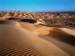
The HMS Beagle set out from Yuma, Arizona and with great enthusiasm headed for San Diego, California, but with Yuma on the Arizona/California border, our trip was almost entirely within California. Also, the course taken by the Beagle was for the most part very close to the US/Mexican border. As we travelled west from Yuma, we were impressed with the increasing aridness of the desert, which included miles of sand dunes and some very high hills. Here and there, we saw people in dune buggies exploring the dunes. The official name of the area is Algodones Dunes and refers to the entire geographic feature, while the administrative designation for that portion managed by the Bureau of Land Management is the “Imperial Sand Dunes Recreation Area” (sometimes called the “Glamis Dunes”). The Algodones Sand Dunes are the largest mass of sand dunes in California. This dune system extends for more than 40 miles (60 km) along the eastern edge of the Imperial Valley agricultural region in a band averaging 5 miles (8 km) in width. The dune system is divided into 3 areas. The northernmost area is known as Mammoth Wash. South of Mammoth Wash is the North Algodones Dunes Wilderness established by the 1994 California Desert Protection Act. This area is closed to motorized use and access is by hiking and horseback. The largest and most heavily used area begins in the south near Interstate 8. The expansive dune formations offer picturesque scenery, a chance to view rare plants and animals, and a playground for ATV and off-roading enthusiasts. The dunes are also popular in film-making and have been the site for movies such as Return of the Jedi.
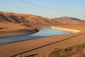
Also, there is a canal called the All-American Canal that follows the highway for many miles and runs parallel to the Mexico/California border. The All-American Canal is an 80-mile (130 km) long aqueduct that conveys water from the Colorado River into the Imperial Valley and to nine cities. It is the Imperial Valley’s only water source, and replaced the Alamo Canal, which was located mostly in Mexico. The Imperial Dam, about 30 miles (48 km) northeast of Yuma, Arizona on the Colorado River, diverts water into the All-American Canal, which runs to just west of Calexico, California before its last branch heads mostly north into the Imperial Valley. Five smaller canals branching off the All American Canal move water into the Imperial Valley. These canal systems irrigate up to 630,000 acres (250,000 ha) of crop land and have made possible a greatly increased crop yield in this area, originally one of the driest on earth. It is the largest irrigation canal in the world, carrying a maximum of 26,155 cubic feet per second (740.6 m3/s). Agricultural runoff from the All American Canal drains into the Salton Sea. With over 500 people having drowned in the canal since 1997, it has been called “the Most Dangerous Body of Water in the U.S.”
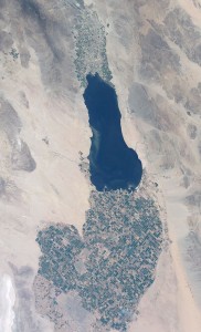
The Colorado River is a river in the southwestern United States and northwestern Mexico, approximately 1,450 miles (2,330 km) long, draining a part of the arid regions on the western slope of the Rocky Mountains. The natural course of the river flows from north of Grand Lake, Colorado into the Gulf of California. For many months out of the year, however, no water actually flows from the United States to the gulf, due to human consumption. So to connect the dots here, what is really happening is that the water from the Colorado River has been diverted to the All-American Canal which irrigates the Imperial Valley for agriculture and returns it back to the Salton Sea. Very little or no water actually gets to Mexico down the Colorado. Below is a photo from space showing the Salton Sea and the Imperial Valley. One can plainly see the line which is the US Mexican border as a diagonal sloping down left to right. above the border the valley is green, below the border not so green. Imagine that?
The area has been a infamous example of the interference by humans with nature. Take for example the Salton Sea which is is a shallow, saline, rift lake located directly on the San Andreas Fault, predominantly in California’s Imperial and Coachella valleys. The lake occupies the lowest elevations of the Salton Sink in the Colorado Desert of Imperial and Riverside counties in Southern California. Its surface is 234.0 ft (71.3 m). below sea level. The deepest point of the sea is 5 ft (1.5 m) higher than the lowest point of Death Valley. The present day Salton Sea was accidentally created by the engineers of the California Development Company in 1905. In an effort to increase water flow into the area for farming, irrigation canals were dug from the Colorado River into the valley. Due to fears of silt buildup, a cut was made in the bank of the Colorado River to further increase the water flow. The resulting outflow overwhelmed the engineered canal, and the river flowed into the Salton Basin for two years, filling the historic dry lake bed and creating the modern sea, before repairs were completed.
While it varies in dimensions and area with fluctuations in agricultural runoff and rainfall, the Salton Sea averages 15 miles (24 km) by 35 miles (56 km). With an estimated surface area of 343 square miles (890 km2) or 350 square miles (910 km2), the Salton Sea is the largest lake in California. The average annual inflow is less than 1,200,000 acre feet (1.5 km3), which is enough to maintain a maximum depth of 44 feet (13 m) and a total volume of about 6,000,000 acre feet (7.4 km3). However, due to changes in water apportionments agreed upon for the Colorado River under the Quantification Settlement Agreement of 2003, the overall water level of the Sea is expected to decrease significantly. The lake’s salinity, about 44 grams per litre (0.0016 lb/cu in), is greater than that of the waters of the Pacific Ocean (35 g/L (0.0013 lb/cu in)), but less than that of the Great Salt Lake (which ranges from 50 to 70 g/L (0.0018 to 0.0025 lb/cu in)). The concentration grows at a rate of about one percent per year. About 4,000,000 short tons (3.6×10⁹ kg) of salt is deposited in the valley each year.
Travelling through the Imperial Valley one sees vast acres of irrigated fields. There are many almond, walnut and pistachio orchards. but what one sees most are acres of grass for making hay. In these huge fields of grass there are, “in the terminology of the United States Environmental Protection Agency (EPA), Concentrated Animal Feeding Operations (CAFO) A CAFO is an animal feeding operation (AFO) that (a) confines animals for more than 45 days during a growing season, (b) in an area that does not produce vegetation, and (c) meets certain size thresholds. The EPA’s definition of the term “captures key elements of the transformations” observed in the animal agriculture sector over the course of the 20th century: “a production process that concentrates large numbers of animals in relatively small and confined places, and that substitutes structures and equipment (for feeding, temperature controls, and manure management) for land and labor.” In essence there are thousands of cattle under acres of tin roofed sheds in the desert eating irrigated hay.
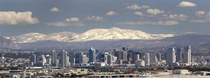
Leaving the Imperial Valley, the Beagle had to cross the Cuyamaca Mountains to get to San Diego. The Beagle had to climb from below sea level to about 4,200 ft above sea level to get through the mountain passes. The grades were fairly steep in some sections. The highway authorities posted signs to turn off air conditioning to reduce the stress on vehicles. They also provided radiator water every quarter mile or so. The Beagle was able to make the journey unscathed and began the descent to San Diego. The Crew was not completely prepared for how mountainous southern California really is. In the picture below one can see the Cuyamaca Mountains behind the skyline of San Diego.
The Beagle moored safely at Rancho Los Coches RV Park in Lakeside California, a few miles out of the centre of the San Diego. Here Mr. Darwin had ample room to observe nature and scurry about. One of the attractions of Los Coches was a creek valley running quite near the the Beagle’s moorings, technically part of Cañada Los Coches, or valley of the pigs. Mr. Darwin was able to explore the creek actively. He spotted several ducks and other wildlife which he enthusiastically pursued. From Los Coches the crew was able to visit San Diego, the subject of other posts.